The US Interstate System
...and a little more.
I was raised (there are varying opinions on that idea but that's another story) to believe that airplanes took off for one reason. To crash. I honestly think that my late mother truly believed that. Of course, in the 60's (er, 1960's before you adjust that), when I was, in theory, at my most influential time of growth in what I believe, it didn't occur to me and apparently to her either, for that matter, that if her notion held water, multiple crashes would be occurring each and every hour. Okay, so what has this to do with the intersate system header at the top of the page? Well, it's my way of "laying a foundation," if you will.
In 1987, much to my mother's consternation and confirmation that "Ron does things his way, believes the way he chooses and has chosen to answer to nobody but the Lord Jesus Christ," I signed up for flying lessons. I know, it must seem to the unintiated (to my madness) that I'm wandering off yet again, however, if you stay with me, this is part of "the story."
So, the interstate system, which was initially thought up and eventually designed was done so for a purpose. No, the purpose wasn't for Mom & Pop and their respective herds of off-spring to head out on, for a vacation, although that did commence fairly early on. The original idea came as a solution for transporting our military, from border-to-border, as quickly as possible (land based trucks and troop carriers), during a time when the idea of an invasion by not-so-friendly countries was considered a real and serious concern.
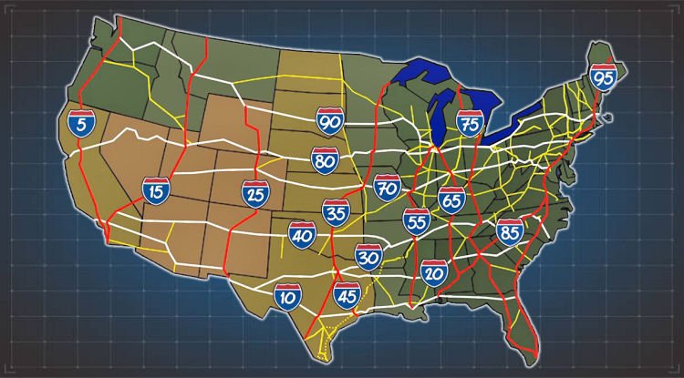
There's an old adage that basically says "If you don't know where you're going, any road will get you there." Well, the same could be said for our interstate (and likely still is, by current drivers on it). Common-sense (we abuse this in the south as we strive to stay away from logic) demanded that the system have some form of ability for navigation and voilà, the interstate numbering system was born. And here, folks, is the non-perfect explanation of how the system works.
Even Numbers (East–West): Routes like I-10 or I-80 run horizontally, while odd numbers, (North–South): Routes like I-5 or I-95 run vertically.
Geographic Grid Pattern
To help with navigation, the numbers increase in specific directions across the national grid:
• South to North (Even): Lower even numbers are in the south (e.g., I-10 in Florida/California) and increase as you move north (e.g., I-90 in Washington/Massachusetts).
• West to East (Odd): Lower odd numbers start in the west (e.g., I-5 along the Pacific Coast) and increase as you move east (e.g., I-95 along the Atlantic Coast).
• Major Arteries: The most significant cross-country routes typically end in 0 (East–West) or 5 (North–South).
Allow me to give you an example.
Remember the "flying lessons?" Well, when you are learning to fly, you do so using what is called "VFR" (Visual Flight Rules), as opposed to "IFR" (Instrument Flight Rules - a more advanced/complex system allowing for flying in inclement weather, etc.).
I, of course, followed the VFR. Now, when I met my wife (God Bless her, she's still with me) and asked her out for a first date, she declined but that's a whole 'nother story. When she ultimately conceded, accurately figuring out it may serve to get me to leave her alone, I went and picked her up, saying "we'll go and get some dinner." It wasn't until we got to the airport and I showed her how to strap into the aircraft that she concluded this wasn't going to be a routine, run-of-the-mill first date.
We took off from BTR (Baton Rouge Metropolitan Airport in Baton Rouge, Louisiana) and headed west, following I-10 to the small community of Jennings, Louisiana, where, at least at the time, one could land at their airport (within sight and just off of I-10) and literally taxi right up to the Holiday Inn restaurant. Now, I mention this because as I pointed out, I followed I-10, which was in plain view, below us at 1500 feet. For those familiar with the area, this route took us directly over the Atchafalaya Basin, or Atchafalaya Swamp, which is the largest swampy wetland in the United States. Therefore, in the event of an unforeseen emergency, I would have much preferred the option of setting down on the interstate as opposed to one of the swamp's natural residents.
I know, folks, this in't one of your typical "informative" type of postings. But in my defense, it is a blog and as you no doubt know, 'anything goes' in one of these. I just promise to keep it clean and as readable as my non-mastery of the english language permits.
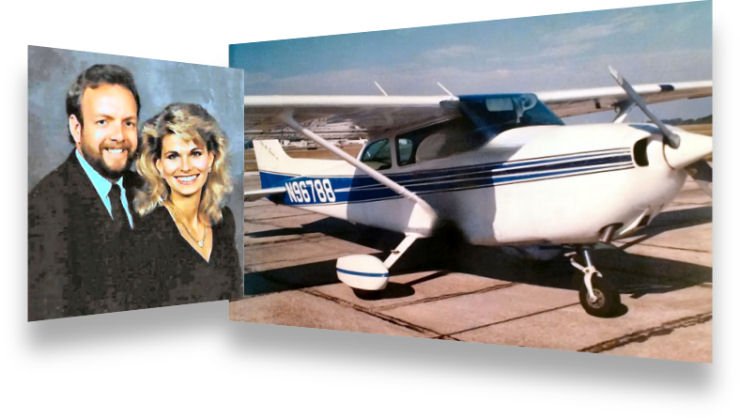
I'll leave you with a photo of my wife and I (taken two months before we were married in 1989), alongside the aircraft in which I flew her on our first date.
What's Your Reaction?